APH
APHFrom The Irish Times 12 August 1986
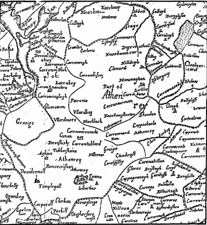
FIVE of the Tribes of Galway -Kirwin, Darcy, French, Browne and Blake – were landowners in the parish of Athenry, contained within the broken fine on the above map of Sir William Petty of 1685, about the year 1641. The Burkes, one of the most important and most numerous Hiberno-Norman families, Earls, and later Marquesses of Clanricarde, were also ensconced there. The Galway “Book of Survey and Distribution, 1636-1703” does not reveal the religion of these and other landowners, and therefore it is difficult to know if disaffection or religion was the cause of their losing, or being granted land, as the case might be. Indeed, titled people, the Earl of St Albans and Lord Clanmaurice (or Clanmorris) were numbered among the forfeiters.
The former lost land at Crequile, Poletulan (Poletulla on map), Lisnekerkie (Lios na Circe), the ringfort of the hen), Knockmore, Killarrow, Garranebrannoge, Glasshegannie, Carrowkeale Ceathru Chaol, (narrow quarter), Knockerdally, Ferlie (probably Farronie on map), Lios na gCapall, the ringfort of the horses), Bracklonebeg, Lisquill and Ballyworrie. Among Lord Clanmaurice’s losses were acres at Bruskagh (Briskagh), Abbott (at the very top of map), Carrowmore, Derrynateghell (Derrinathall on map, probably Doire an tSeagail, the oak-grove of the rye), Knockanecarr (Knockanm Carra), Curfarine and Karroliskoyle. Losers among the natives were Donnogh O Dalye at Carrowkillew. and Turoe; Donnell mc Swinie at- Kiltullagh (called Garreduffe) and Killeskreagh; Teige o. Kelly at Graige, Carrowmore, Knockanecarra and Lissnisky, and William Oge Dolphin Esq. at Turoe. Dolphin, a family of Norse origin came to Connaught from England, settling in Galway, becoming completely hibernicised,
The vast majority of the confiscated land went to the Earl of Clanrickard, but also to Lord Trimblestowne the Duke of Ormond and Nicholas Browne, with the Daleys, Darceys, Kellys, Morrisses and Rochford, also benefitting. Thomas Smith, Edward Oge O Heher, Richard Martin, Countess Mountrath, John Shea, Richard Davock and Tibbot Oge mc Cooge shared the forfeited land of the McAnocks Richard, Hubert, Tybot and James, at Derrydonnell. Edward MacLysaght’s “The Surnames of Ireland” has MacCoog as being the same as Cooke, which name in Connaught is the modern anglicised form of MacDabhoc (?Davock above). To further entwine matters, the Mac Dabhoc family is a branch of the Burkes. This book does not have McAnock, nor can we discover anything therein resembling it. The area engraved like a lake on the top left-hand corner of the map, has no corresponding lake, big or small, on present day maps. However, it is =marked “tirlogh” (turlogh), out of top of map, this being defined as “depressions in the surface with subterranean drainage which, owing to the proximity of ther floors to the level of the permanent water, flood up in wet weather, forming lakes for longer or shorter periods . . .” It would appear that it was during such a period that this arca was surveyed.
In 1837 there was a population of 12,185 of which 1,319 resided in the town’s 250 houses. The town also had a constabulary police force station, a church described as “a very neat edifice, built about the year 1828” and the chapel being “a plain slated building”. A coal-pit had been opened at Castle Lambert some years prior to the compilation of Lewis’s “Topographical Dictionary of Ireland, 1837”, but has soon been discontinued. There was a parochial school for 55 boys and 35 girls, and four private pay schools catered for 240. There was also a church at Monivea (then spelled Monivae), with a school for 30 boys and 30 girls. Lewis mentions some remains of the ancient walls of Athenry, and one: of the gates, and the ruins of Dominican and Franciscan- monasteries.
The principal “seats” were “Castle Lambert” of W. Lambert Esq. and “Athenry House” of J. Lopdell Esq., on which was situated the ‘inevitable “chalybeate spring”, which Lewis recounts “is much resorted to”.